When Should I Plan a ski Trip to Utah?
A Climatological Look at Powder Days in the Wasatch
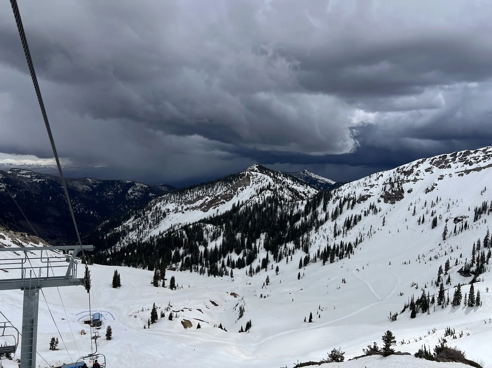
Thunderstorms approach Snowbird, UT
Background
Growing up, my family would drive to New England yearly for a ski trip to wherever our time-share could bring us. We’ve skied Massachusetts, Vermont, New Hampshire, Maine, and everyone in my family except for me has skied New York. Every trip was planned over spring break, which was usually the end of March, and sometimes the first week of April. I have fond memories of skiing in 70 degree weather at Waterville Valley for $1 on April 1st. On the other hand, some years we would get lucky with feet of snow. The biggest snowflakes I remember were outside of Powder Hounds, located near Jimminy Peak in the Berkshires.
This years dismal winter out west came with lots of complaints regarding holiday reservations but no snow. While I understand folks being upset about crappy conditions during a trip they planned months or years in advance, as a family we never had that luxury. We got the lecture “conditions might suck or they might be great— either way were going to have a good time.” And we are better off for it.
Now, as an adult with a toolbox full of data analytics, I found myself asking “ is there a time during the ski season where powder days are more common?” No snow, on the other hand? That downright sucks and that’s a different question to explore at a later time. In the meantime, if you are trying to chase powder in Utah, timing does matter.
Not every week during ski season has the same odds of delivering a powder day, and while skiers often talk about snowfall in terms of seasonal totals, that does not necessarily answer the question most visitors actually care about:
During what time of the ski season am I most likely to wake up to fresh snow during my trip?
Methodology
To explore that question, I analyzed nearly 40 years of SNOTEL data (1986–2025) from several northern Utah ski regions to identify when powder days are climatologically most likely to occur.
Rather than focusing on total snowfall, I looked at the probability of receiving at least 4 inches of snow in a 24-hour period. Four inches may not qualify as an all-time “deep day” by Utahn’s standards, but it is enough to noticeably improve ski conditions and serves as a useful threshold for identifying meaningful overnight snowfall.
Using daily snow water equivalent (SWE) observations from NRCS SNOTEL stations and assuming a 10:1 snow-to-liquid ratio, I calculated the historical probability of a powder day for every day of the year. I used station data at or near Snowbird/Alta, Brighton/Solitude, and Park City/Deer Valley. The results are essentially a climatological guide to when skiers are most likely to encounter fresh snow during their trip to the Wasatch.
The results
Snowbird/Alta - our winners
The strongest signal appeared in Little Cottonwood Canyon, home to Snowbird and Alta.
Using a Snowbird-area SNOTEL station as a proxy for Alta and Snowbird, the probability of a powder day peaks near 29% during the heart of winter in the first two weeks of January. The second peak occurs at the end of March and third peak occurs mid February. Based on these results, Snowbird and Alta offer extreme flexibility while maintaining a high likelihood of delivering a powder day of more than 4 inches throughout the entire ski season but the end of March seems to be a planners best bet.
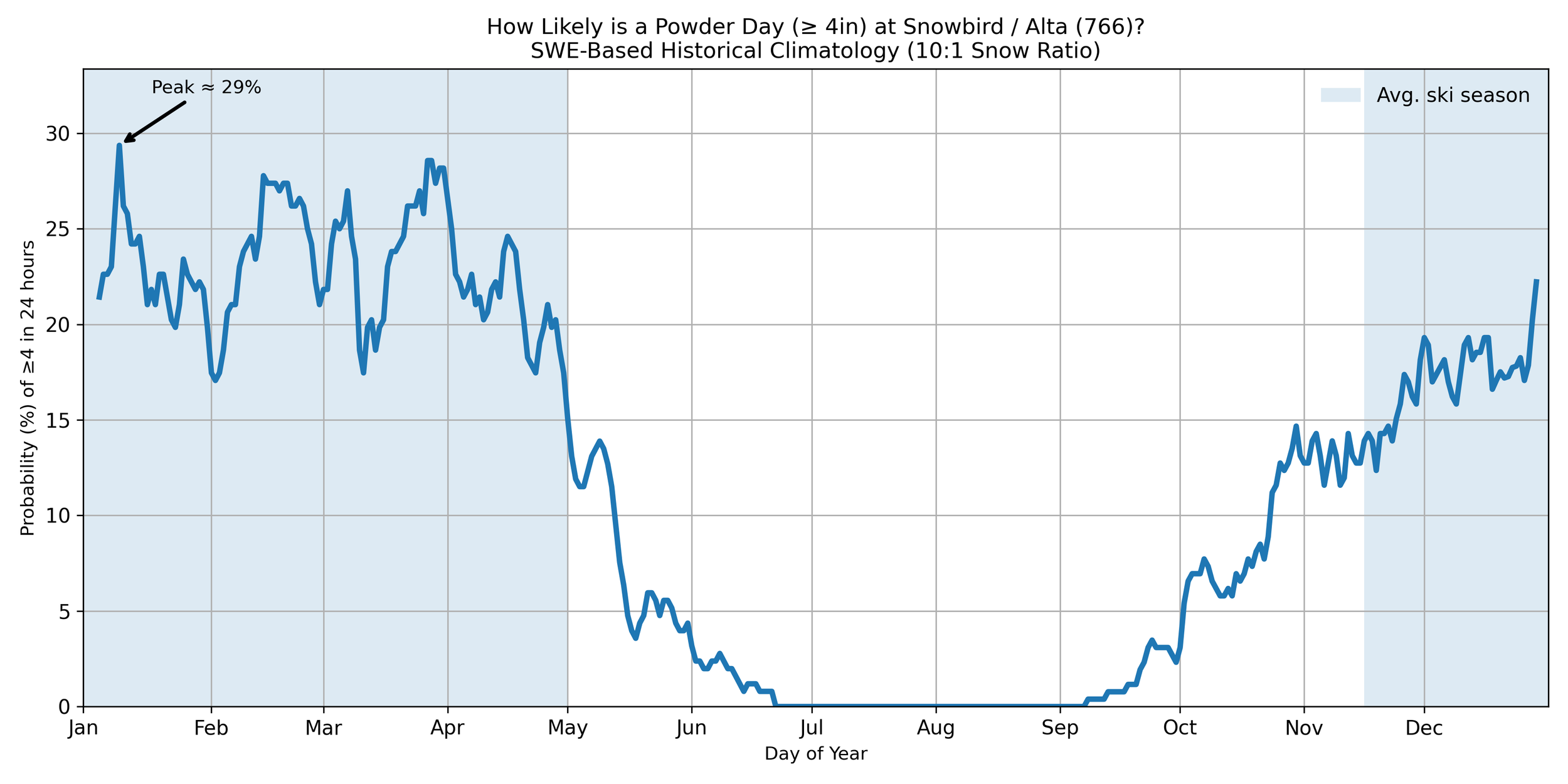
Graph showing probability of snowfall greater than or equal to 4 inches of snow for Snowbird and Alta, using SNOTEL Station 766 as a proxy.
Climatological “Best” Days at Snowbird / Alta
January 9, with a 29.37% likelihood of a powder day (≥4 inches)
March 28, with a 28.57% likelihood of a powder day (≥4 inches)
March 27, with a 28.57% likelihood of a powder day (≥4 inches)
March 31, with a 28.17% likelihood of a powder day (≥4 inches)
March 30, with a 28.17% likelihood of a powder day (≥4 inches)
In summary, the day that has the highest likelihood of a powder day at Snowbird/Alta is January 9th — consider planning a trip around that day. To maximize powder days, however, the end of March seems like the best time to ski Snowbird/Alta with March 28, 27, 30, and 31 all having a high probability of having a powder day.
Brighton/Solitude - Ol’reliable
Brighton and Solitude in Big Cottonwood Canyon showed similarly strong probabilities, though slightly lower compared to Snowbird/Alta in Little Cottonwood Canyon. The climatological peak of the powder season occurs in early January through late February, with January 9 showing the highest probability of a powder day (≥4 inches) at 19.78%. January 8 (18.68%) and February 20 (19.05%) also rank among the top dates, highlighting mid-winter as the most reliable period for fresh snow. A secondary peak emerges in late March and early April, with March 27 (18.32%) and April 1 (17.95%) rounding out the top five.
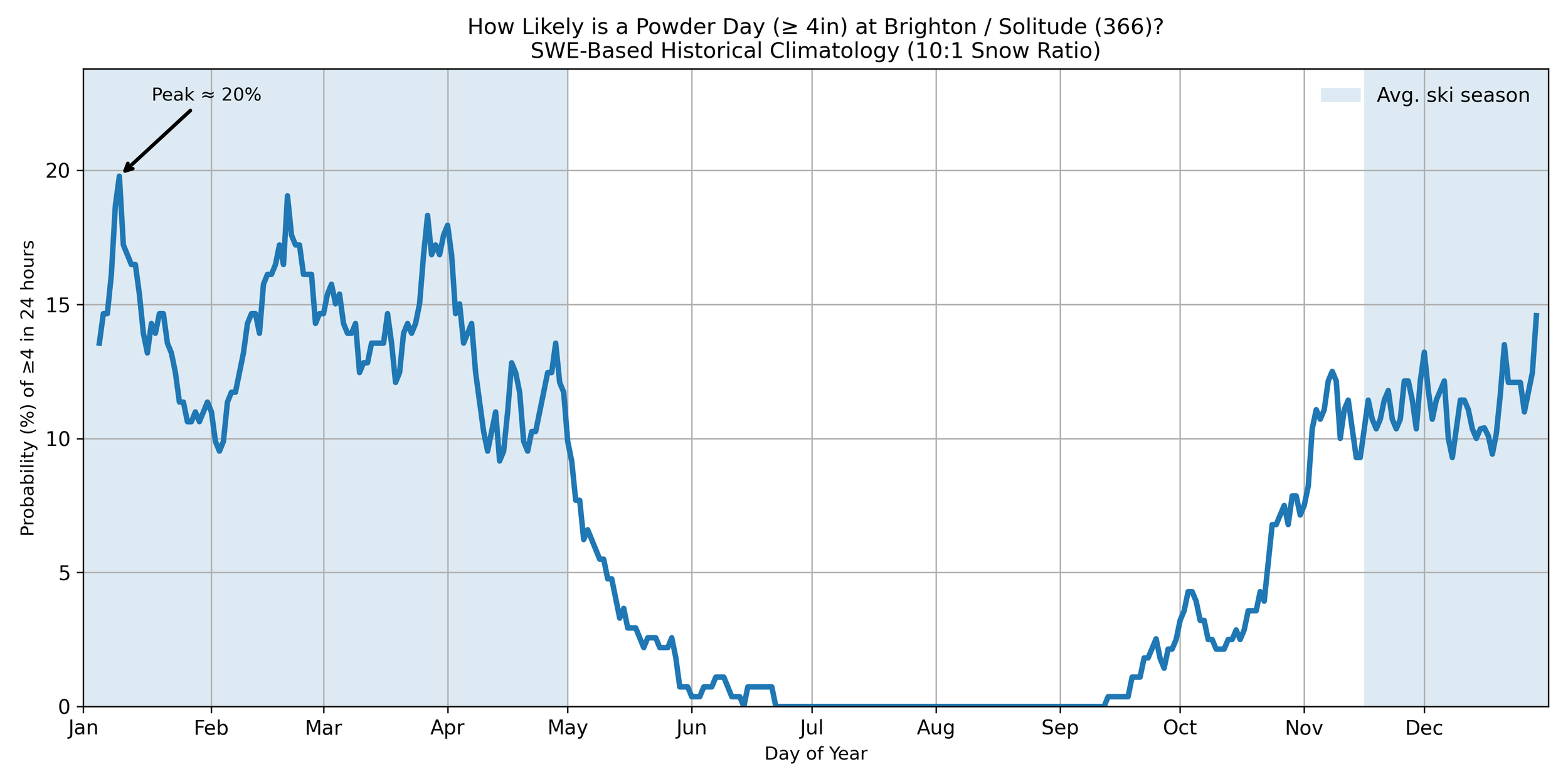
Graph showing probability of snowfall greater than or equal to 4 inches of snow for Brighton and Solitude, using SNOTEL Station 366 as a proxy.
Climatological “Best” Days at Brighton/Solitude
January 9, with a 19.78% likelihood of a powder day (≥4 inches)
February 20, with a 19.05% likelihood of a powder day (≥4 inches)
January 8, with a 18.68% likelihood of a powder day (≥4 inches)
March 27, with a 18.32% likelihood of a powder day (≥4 inches)
April 1, with a 17.95% likelihood of a powder day (≥4 inches)
In practical terms, this means that if you planned a ski trip around the climatological peak, you start to maximize your odds of encountering at least one powder day during your visit. If you planned your trip around multiple peaks you maximize the odds of having a powder day at least once over the course of a week. In the case of Brighton/Solitide, the second week of January and last week of March into April seem to be the best weeks to plan a ski trip.
Of course, no individual day guarantees snowfall. But over a week-long trip, clustering your travel around the seasonal peak materially improves the odds. However, let’s appreciate the fact the the odds of a 4 inch powder day are never 0% in Big or Little Cottonwood Canyons.
Park City and Deer Valley Tell a Different Story
The Park City side of the Wasatch showed a noticeably different climatology— but still offer fun skiing nonetheless (shoutouts to no 0% days during the ski season!).
Using the Thaynes Canyon SNOTEL station as a proxy for Park City Mountain and Deer Valley, peak powder-day probabilities were lower than those observed in the Cottonwoods, topping out at 24% at the end of February. The second peak occurs at the start of January around 21% likelihood of 4 inches of snow or more and then the third peak occurs around the end of March.
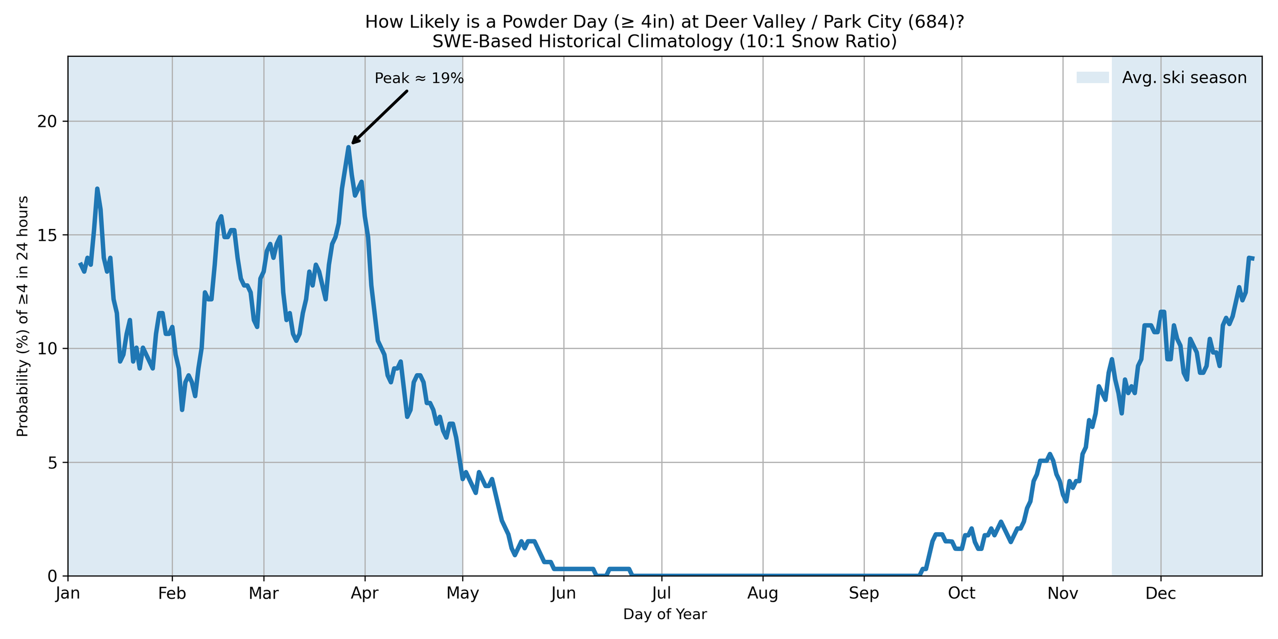
Graph showing probability of snowfall greater than or equal to 4 inches of snow for Deer Valley and Park City, using SNOTEL Station 684 as a proxy.
As a non-local the difference may seem surprising at first but there are a few key differences between the Cottonwoods and Park City that drive climate differences.
One likely contributor is the rain shadow effect associated with the Wasatch terrain and Great Salt Lake. The Cottonwoods are often better positioned to maximize lake effect snowfall, while areas farther east toward Park City can receive reduced precipitation during lake effect snowfall events. Elevation plays a crucial role as well:
Snowbird: 7,760 ft (base) – 11,000 ft (summit)
Alta: 8,530 ft (base) - 11,068 ft (summit)
Brighton: 8,755 ft (base) - 10,500 ft (summit)
Solitude: 7,988 ft (base) - 10,488 ft (summit)
Park City: 6,800 ft (base) - 10,026 ft (summit)
Deer Valley: 6,570 ft (base) - 9,570 ft (summit)
Snowbird and Alta sit roughly 1,500 feet higher than Deer Valley and Park City. Using the average environmental lapse rate of 3.5°F per 1,000 feet, temperatures at Snowbird/Alta are can be about 5°F colder on average—a difference that increases the likelihood of snow instead of rain especially for storms where the temperature is close to the freezing point.
These results do not mean that Park City lacks good snow. But the climatology suggests that the Cottonwoods provide more consistent odds for frequent powder days.
Climatological “Best” Days at Deer Valley / Park City
March 27, with a 18.84% likelihood of a powder day (≥4 inches)
March 26, with a 17.93% likelihood of a powder day (≥4 inches)
March 28, with a 17.63% likelihood of a powder day (≥4 inches)
March 31, with a 17.33% likelihood of a powder day (≥4 inches)
January 9, with a 17.02% likelihood of a powder day (≥4 inches)
Deer Valley and Park City show a clear clustering around the end of March. Four of the five most likely powder days occur between March 26 and March 31, with March 27 ranking highest at an 18.84% probability of receiving at least 4 inches of snowfall. January 9 is the only mid-winter date to break into the top five.
Final Thoughts
What This Study Does—and Does Not—Show
This analysis is intended to describe historical probabilities, not predict individual storms or seasons. There are also several simplifying assumptions:
SNOTEL measures SWE, not snowfall depth directly
Snow-to-liquid ratios vary between storms, I chose 10:1 but the ratio can really be anything
Snow quality depends on more than just total depth alone
Station data is approximate to the ski resort location
Still, long-term climatological records provide useful context for understanding how snowfall likelihood changes throughout the season.
Where This Could Go Next
This project raised several questions that I plan to explore further. Next, I plan to on analyzing different snowfall thresholds. I plan to explore 6-inch and 12 inch powder days! Based on this year’s ski season out west, I also plan to explore 0-inch powder days. Let me know which analysis you would like to see first!
Another offshoot from this project is to explore multi-day snowfall events to historically understand during what time of the year they are most common.
I am also interested in expanding the analysis to go beyond Utah. Let me know where you which area you would like me to analyze next!
Results summary
Taken together, these results suggest that the last week of March offers the best opportunity for skiers hoping to maximize their chances of finding powder across all six major Wasatch resorts. While Snowbird and Alta maintain strong powder potential throughout the winter, late March is the period when Deer Valley, Park City, Brighton, Solitude, Snowbird, and Alta all simultaneously exhibit elevated powder-day probabilities, making it an ideal target window for a destination ski trip to Utah.
This analysis serves as a decision support tool for skiers by identifying when historical odds of a powder day are highest at Utah's major resorts. Use this to plan your next ski trip and let me know how it turns out. Consider this a disclaimer: just because the probabilities are highest doesn’t mean a powder day is promised. Do with this information what you will!