El Niño Won't Save our Ski Season (And La Niña Didn't Ruin It)
Utah just came off its worst snowpack winter on record. Now a "super" El Niño is spinning up in the Pacific, and everyone's trading theories about what that means for this season.
Here's the problem with those theories: 2025-26 wasn't even an El Niño winter. It was La Niña (fading to neutral), which is the pattern Utah skiers usually root for, and it still produced the worst snowpack on record.
So before anyone reads this year's tea leaves off the ENSO forecast, it's worth asking a more basic question: does El Niño/La Niña actually move the needle on Utah's winter temperature at all?
I pulled 35 years of data to find out.
The Setup
Snowpack is the number people care about, but temperature is the final boss. A storm can dump plenty of moisture and still produce garbage snow if the air it's falling through is too warm. In my last project, I found that warm temperatures is what caused last year to be so lame in Northern Utah. Precipitation was near normal but temperature was not. I mainly explored the relationship between ENSO phase and snowfall amounts. Since that didn’t lead to much, I decided to explore the relationship between ENSO and temperature in Northern Utah to see if there is any correlation.
This project asks the question one level up: does the phase of ENSO reliably predict Salt Lake City's winter temperature? And does temperature itself predict what skiers actually care about — powder days?
NOAA's Oceanic Niño Index (ONI), ERA5 reanalysis temperature data back to 1992, and an estimated powder-day count built from SNOTEL snow-water-equivalent data (more on that estimate below) were the datasets used to complete this study.
ENSO Explains Almost Nothing About Northern Utah's Winter Temperature
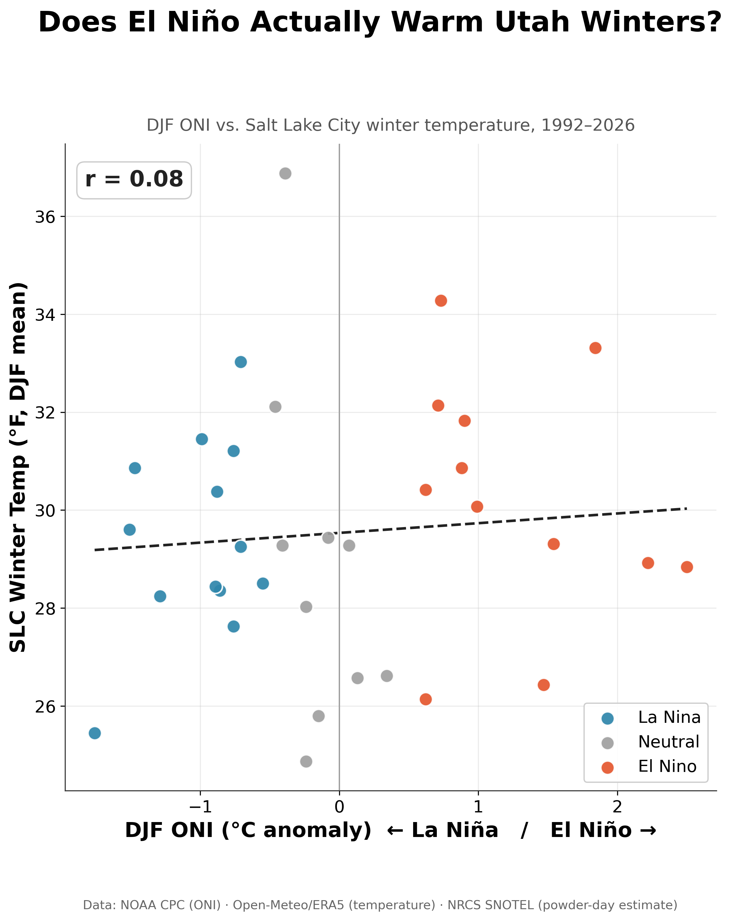
The correlation between DJF ONI and Salt Lake City's winter mean temperature is r = 0.08. Zero means no relationship and 1.0 means a perfect relationship. An R equal to 0.08 indicates a very weak relationship, if any at all. Whatever El Niño and La Niña are doing to the atmosphere, it isn't showing up as a strong temperature signal here.
The single warmest winter in the record, the 2025-2026 winter (averaging at nearly 37°F) sits in the La Niña/Neutral ENSO category, not an extreme phase. The worst temperature-driven snow year in three decades happened when ENSO wasn't doing anything unusual at all.
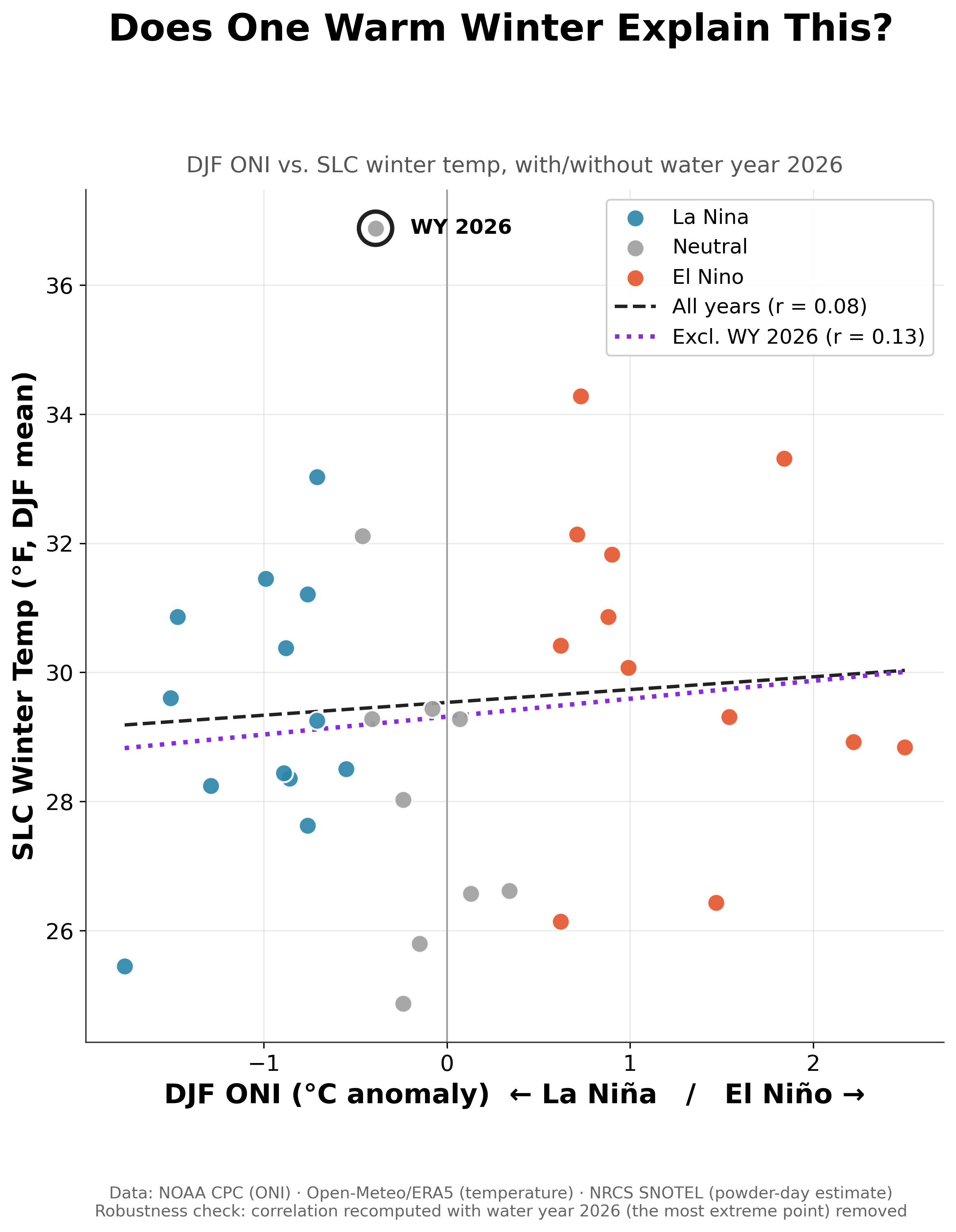
I pulled out the most extreme year, this past season, as a sanity check to see if it would improve the correlation at all. Refitting the trend with that record-warm winter excluded entirely moved the needle, but only slightly. The correlation moves from 0.08 to 0.13, which is still weak, though still positive.
Grouping by ENSO Phase Doesn't Rescue the Story
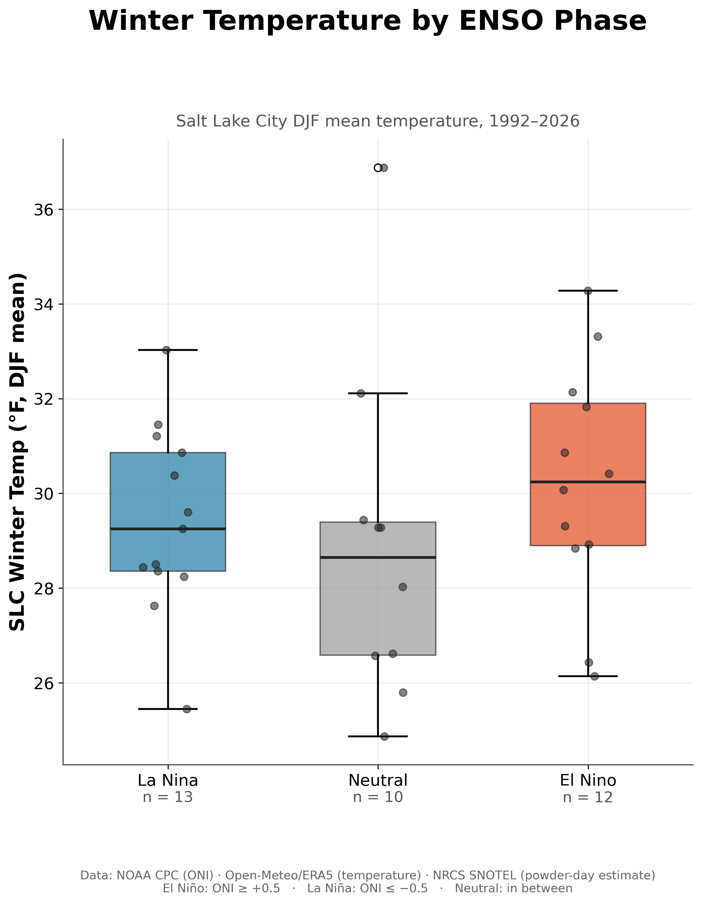
Split the same years into La Niña (n=13), Neutral (n=10), and El Niño (n=12) and look at the distributions. El Niño winters trend slightly warmer on median. Neutral winters trend slightly cooler — counterintuitive, given the record-hot winter sits in that group.
But "slightly" is the key word: the spread within each category dwarfs the difference between categories. A cold La Niña winter and a warm La Niña winter are further apart than the typical La Niña winter is from the typical El Niño winter.
Does Temperature at Least Predict the Skiing?
Even if ENSO doesn't move temperature much, maybe temperature predicts powder days directly.
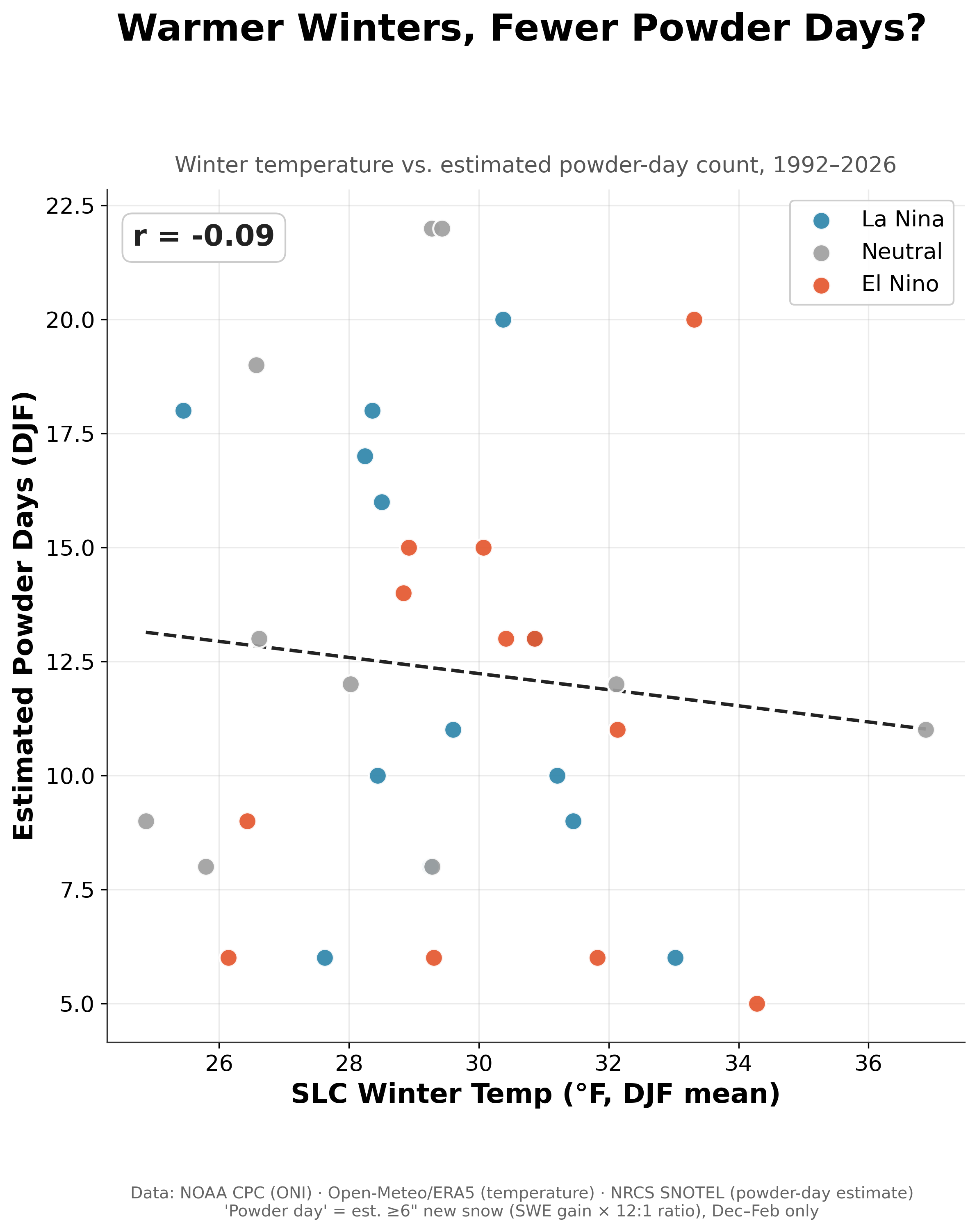
We find a negative r value this time but it’s still weak, sitting at -0.09. Again, if I remove the extreme season from the results, it’s doesn’t move the needle too much.
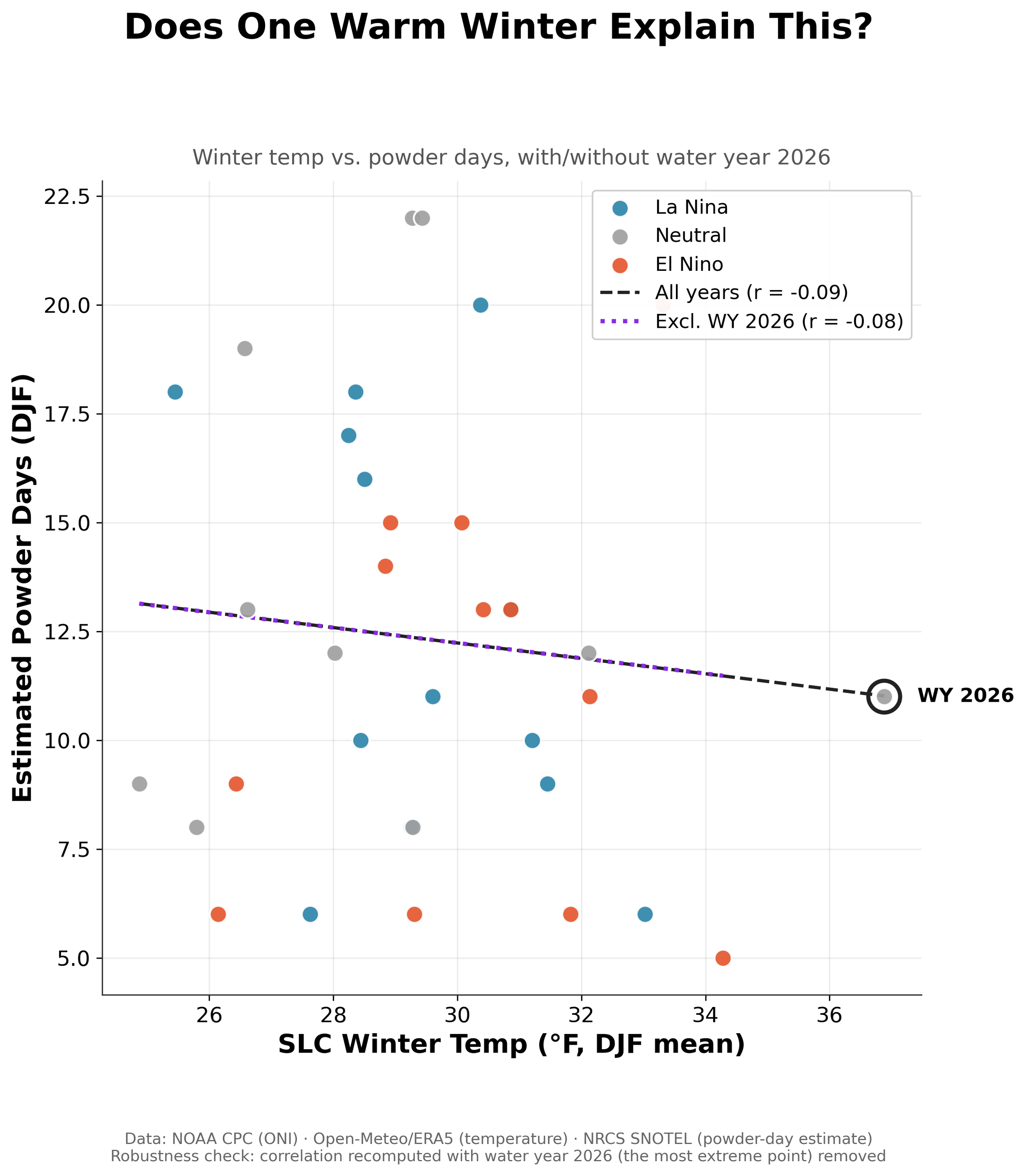
Results are also close to nothing: r = -0.09, barely moving to -0.08 with the extreme year removed. Warmer winters trend toward slightly fewer estimated powder days, but too weakly to build a proper forecast.
Tying It Back to the snowfall Study
My last project compared SWE against ONI directly, and the pattern rhymed: a weak relationship. However, upon, eyeballing the figures you’ll notice a hint that the least extreme ENSO years sometimes produced above-average snowpack. I had a hunch but didn’t have it proven.
So, I completed two analyses with two different angles and both came to a similar conclusion: ENSO is a weak indicator for Northern Utah. Utah sits almost exactly on the seam between the Pacific Northwest's La Niña-favored wet pattern and the Southwest's El Niño-favored dry pattern, close enough to both that neither cleanly wins here.
If ENSO isn't the main driver, something is still setting week-to-week outcomes. The more likely suspects are shorter-lived patterns — the Pacific-North American (PNA) pattern and the Madden-Julian Oscillation (MJO) — that shift over weeks, not seasons.
Because there are always Caveats
35 winters is a small sample, and three ENSO groups leaves only 10-13 points each — enough to see a pattern, not enough to trust a precise number.
"Powder day" is an estimate, not a measurement. SNOTEL measures snow-water-equivalent, not depth; we converted SWE gain to snowfall using a 12:1 ratio that varies storm to storm in reality. Results probably would change with a different ratio.
One city stands in for a state. Salt Lake City is a reasonable proxy for the Wasatch corridor but is not a statewide average nor does it perfectly reflect mountain meteorology.
Local Climate. Salt Lake City is a valley that since near a large body of water in the middle of the desert. Weather in Salt Lake City is impacted heavily by local geography which might dampen a larger relationship that the state of Utah could have with ENSO.
Small-sample correlations are fragile where one unusual year can swing a coefficient more than people expect. Both correlations held up without it, which is the strongest evidence we have that this isn't a fluke.
Correlation is linear; the atmosphere is not. r = 0.08 rules out a straight-line relationship but the climate is complex and ENSO has an impact on global climate patterns. To say there is absolutely no relationship between Northern Utah weather and ENSO is naive but the data for Salt Lake City supports a weak relationship.
The Takeaway
If you're trying to figure out whether this Super El Niño winter will be good or bad for Utah skiing, the honest answer is: ENSO alone won't tell you. Last year's disappointment happened during La Niña, the phase Utah skiers usually like, but the culprit was a warm airmass that made snow fall as rain.
Because El Niño years trend warmer, I’m skeptical that this year will be anything earth shattering, given the strong El Niño forecast. One positive to warm air is that it can hold more moisture. More moisture = more snow (in theory). So if we do have warmer air moving through northern Utah, let’s just hope it runs into a colder airmass at the Wasatch front let orographic lifting do it’s job.
Based on the results of this study, the ENSO phase doesn’t give us a clear idea as to what this upcoming season will look like. I’m not saying that ENSO has no effect on weather in Utah. I’m just saying it’s not a crystal ball indicator, unfortunately. It’s possible that what actually decides a season plays out week by week, storm by storm, and won't be visible until we're inside the season itself. Less satisfying results than a headline about El Niño and an upcoming crazy ski season — but it's what the data supports.
Next up, I plan on pulling in PNA and MJO indices to see if shorter-timescale patterns explain more of Utah's winter variability than ENSO does — and a look at what genuine Super El Niño analogs (1997-98, 2015-16) meant for snowfall across the wider Western US. I plan on completing similar research for the PNW, per a followers request. Stay tuned! And thanks for reading.
